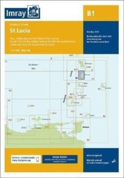
Imray Chart B1 : St Lucia : 1 - 2021 (ISBN: 9781786793119)
Imray Chart B1 : St Lucia : 1 - 2021 (ISBN: 9781786793119)

Ajánlataink Imray Chart B1 : St Lucia : 1 - 2021 (ISBN: 9781786793119) termékre
Ajánlataink a termékre

Vásárlási Garancia
Vásároljon közvetlenül az Árukereső.hu oldalán problémamentesen!
A Vásárlási garancia szolgáltatásunk minden olyan megrendelésre vonatkozik, amelyet közvetlenül az Árukereső.hu oldalán keresztül ad le a Megvásárolom gomb megnyomásával.
Hisszük, hogy nálunk problémamentes a vásárlás, így nem félünk azt garantálni.
-

90 napos termék visszaküldés
-

Árgarancia
-

A pénze biztonságban van
-

Nincs több probléma a megrendelt termékkel
-

Nincsenek megválaszolatlan kérdések
Vásárlás közvetlenül az Árukereső oldalán
A Megvásárolom gomb megnyomásával az adott boltba történő átkattintás nélkül már az Árukereső.hu-n keresztül megrendelheti a kiválasztott terméket, leegyszerűsítve ezzel az online vásárlás folyamatát.
-

Velünk garantáltan problémamentes a vásárlás
-

Kitől is rendel valójában?
-

Milyen fizetési és átvételi módok választhatók?
Paraméterek, termékleírás - Imray Chart B1 : St Lucia : 1 - 2021 (ISBN: 9781786793119)
| Címkék | Térkép |
Hibát talált a leírásban vagy az adatlapon? Jelezze nekünk!
This edition includes the latest official data combined with additional information sourced from Imray's network to make it ideal for small craft. It includes the latest official bathymetric surveys. There has been general updating throughout.
Oldalainkon a partnereink által szolgáltatott információk és árak tájékoztató jellegűek, melyek esetlegesen tartalmazhatnak téves információkat. A képek csak tájékoztató jellegűek és tartalmazhatnak tartozékokat, amelyek nem szerepelnek az alapcsomagban. A termékinformációk (kép, leírás vagy ár) előzetes értesítés nélkül megváltozhatnak. Az esetleges hibákért, elírásokért az Árukereső nem felel.
